
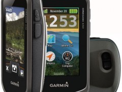
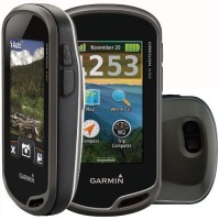

GPS Garmin Oregon 650
Perhatian!
Spesifikasi GPS Garmin Oregon 650
GPS GARMIN OREGON 650

Physical & Performance:
Physical dimensions 2.4" x 4.5" x 1.3" (6.1 x 11.4 x 3.3 cm)
Display size, WxH 1.5"W x 2.5"H (3.8 x 6.3 cm); 3" diag (7.6 cm)
Display resolution, WxH 240 x 400 pixels
Display type transflective color TFT touchscreen
Weight 7.4 oz (209.8 g) with batteries
Battery rechargeable NiMH pack (included) or 2 AA batteries (not included); NiMH or Lithium recommended
Battery life 16 hours
Water rating IPX7
Floats No
High-sensitivity receiver Yes
Interface high-speed USB and NMEA 0183 compatible
Maps & Memory:
Basemap Yes
Preloaded maps no
Ability to add maps Yes
Built-in memory 4 GB
Accepts data cards microSD™ card (not included)
Waypoints/favorites/locations 4000
Routes 200
Track log 10,000 points, 200 saved tracks
Features & Benefits:
Automatic routing (turn by turn routing on roads) Yes (with optional mapping for detailed roads)
Electronic compass Yes (tilt-compensated 3-axis)
Touchscreen Yes
Barometric altimeter Yes
Camera yes (8 megapixel with autofocus; digital zoom)
Geocaching-friendly Yes (Paperless)
Custom maps compatible Yes
Photo navigation (navigate to geotagged photos) Yes
Hunt/fish calendar Yes
Sun and moon information Yes
Tide tables Yes (with optional Bluechart)
Area calculation Yes
Custom POIs (ability to add additional points of interest) Yes
Unit-to-unit transfer (shares data wirelessly with similar units) Yes (plus images and custom maps)
Picture viewer Yes
Garmin Connect™ compatible (online community where you analyze, categorize and share data) Yes
Kelengkapan :
• Softwer Bascame dan Mapsource
• USB cable
• Manual Book
• Battery AA
• AC charger
• Clip carabiner
• Peta Darat dan peta Laut
Alat Ukur Indosurta
PT. Alat Ukur Indosurta ( INDOSURTA GROUP ) adalah perusahaan yang bergerak di bidang Sales, Rental, Service Dan Kalibrasi.
kami menyediakan alat – alat survey, pemetaan dan geologi. Untuk keperluan :
- Kontruksi
- Telekomunikasi
- Kehutanan
- Pertambangan
- Kelauatan
PT. ALAT UKUR INDOSURTA berupaya memberikan konstribusi kepada Masyarakat, Instansi Pemerintah, Swasta dan Perorangan dalam hal penyedia produk – produk Surveying Instrument, Mapping, Geological, Mining, Dan Alat Komunikasi.
Kami akan selalu memberikan pelayanan yang terbaik kepada semua mitra kerja dalam melakukan kerjasama.
Produk – Produk yang kami tawarkan seperti : Total Station, Digital Theodolite, Waterpass, GPS, Statip, Prisma Reflektor, Tribrach, Compass, Clinometer, Tandem, Palu Geologi, Meteran, Pita Survey, Rambu Ukur, Jalo / Pole Stick Prisma, dan berbagai alat survey lainnya.
Segeralah anda mengubungi kami yang senantiasa siap dalam memberikan pelayanan terbaik dan produk yang bermutu guna menunjang kebutuhan dan keberhasilan pekerjaan pengukuran anda.
Kami tidak hanya sekedar menjual produk tetapi dukungan teknis untuk setiap produk yang kami jual. Dengan dukungan tim teknisi kami, kami berusaha memberikan pelayanan terbaik untuk customer.


Produk Lainnya
Printer HP Smart Ink Tank 525 / 520
Rp. 2.375.000
Samsung Mesin Cuci Top Load Inverter
Rp. 4.850.000
Dr.isla Sikat Gigi Electric Beralih
Rp. 109.000

Laoshidaishu Koper Troli 24 Inch Kap
Rp. 358.000

ANGOLA Rak Sepatu Susun Lipat C07-C0
Rp. 207.500