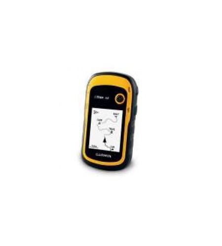

GPS Garmin eTrex 10
Product description Garmin eTrex 10 eTrex H is a successor generation, with a monochrome screen can display information 2.2inc position perfectly. The eTrex 10 has also been using hot fix sattelite technology prediction, that can capture GPS signal quickly and akurat.da And more sophisticated, eTrex 10 GLONASS was able to capture the signal, which is a constellation satelleite position developed by Russia. GLONASS will operate perfectly effective beginning in 2012. With the Glonass, eTrex 10 will more quickly get the position accurately.
Etrex10 also use usb to connect the data to the computer, so you do not have to bother anymore to store your data.
Physical & Performance:
Unit dimensions, WxHxD:
2.1 ” x 4.0 ” x 1.3 ” ( 5.4 x 10.3 x 3.3 cm)
Display size, WxH:
1.4 ” x 1.7 ” ( 3.6 x 4.3 cm) , 2.2 ” diag ( 5.6 cm)
Display resolution, WxH:
128 x 160 pixels
Display type:
transflective, monochrome
Weight:
5 oz ( 141.7 g) with batteries
Battery:
2 AA batteries ( not included) , NiMH or Lithium recommended
Battery life:
25 hours
Waterproof:
yes ( IPX7)
Floats: no
High-sensitivity receiver: yes
Interface: USB
Maps & Memory:
Basemap: yes
Preloaded maps: no
Ability to add maps: no
Built-in memory: no
Accepts the data cards: no
Waypoints / favorites / locations: 1000
Routes: 50
Track log: 10, 000 points, 100 saved tracks
Features & Benefits:
Automatic routing ( turn by turn routing on roads) : no
Electronic compass: no
Touchscreen: no
Barometric altimeter: no
Camera: no
Geocaching-friendly: yes ( paperless)
Custom maps compatible: no
Photo navigation ( navigate to geotagged photos) : no
Outdoor GPS games: no
Hunt / fish calendar: yes
Sun and moon information: yes
Tide tables: yes
Area calculation: yes
Custom POIs ( ability to add additional points of interest) : yes
Unit-to-unit transfer ( shares the data wirelessly with Similar units) : no
Picture viewer: no
Garmin Connect ™ compatible ( online community where you analyze, Categorize and share data) : yes
What’ s in the Box:
-ETrex 10
-USB cable
-Manual
-1 Year warranty