
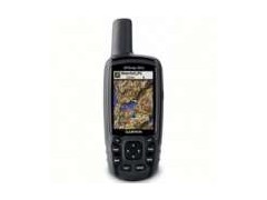
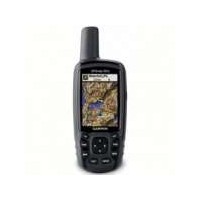

Jual GPS Garmin Map 62SC
Perhatian!
Spesifikasi Jual GPS Garmin Map 62SC
GPS GARMIN GPSMAP 62SC
GPSMAP 62sc handheld navigator features a 3-axis tilt-compensated compass, a barometric altimeter, a 5 megapixel autofocus camera with photo navigation, and support for Custom Maps and BirdsEye™ Satellite imagery ( subscription required) . Rugged and waterproof, GPSMAP 62sc employs a quad helix antenna for unparalleled reception, has a high-speed USB connection and connects wirelessly to compatible handheld devices.
GPS Map 62 minisite
Get Your Bearings
GPSMAP 62sc has a built-in 3-axis tilt-compensated electronic compass, which shows your heading even when you’ re standing still, without holding it level. Its barometric altimeter tracks changes in pressure to pinpoint your precise altitude, and you can even use it to plot barometric pressure over time, which can help you keep an eye on changing weather conditions.
Share Wirelessly
With GPSMAP 62sc, you can share your waypoints, tracks, routes and geocaches wirelessly with other compatible devices. Your friends can enjoy your favorite hike or cache — simply press “ send” to transfer your information.
Document Your Journey
With GPSMAP 62sc` s built-in 5 megapixel autofocus camera, you` ll be able to capture the highlights of your outings. Each photo is automatically geotagged with the location of where it was taken, allowing you — or those you share your photos with — to easily navigate back to that spot in the future.
Keep Your Fix
With its quad helix antenna and high-sensitivity, WAAS-enabled GPS receiver and HotFix® satellite prediction, GPSMAP 62sc locates your position quickly and precisely and maintains its GPS location even in heavy cover and deep canyons. The advantage is clear — whether you’ re in deep woods or just near tall buildings and trees, you can count on GPSMAP 62sc to help you find your way when you need it the most.
BirdsEye™ satellite image
Add Maps
A worldwide basemap with shaded relief comes installed, but adding even more maps is easy thanks to our array of detailed topographic, marine and road options. With 3.5 GB of onboard memory, you can conveniently download 24K and 100K TOPO U.S. maps and hit the trail, plug in BlueChart® g2 preloaded cards for a great day on the water or City Navigator NT® map data for turn-by-turn routing on roads ( see maps tab for compatible maps) . GPSMAP 62sc also supports BirdsEye™ Satellite Imagery ( subscription required) , that lets you download satellite images to your device and integrate them with your maps. In addition, the 62sc is compatible with Custom Maps, free software that transforms paper and electronic maps into downloadable maps for your device.
Get Connected
You` ve been busy exploring and now you want to store and analyze your activities. With a simple connection to your computer and to the Internet, you can get a detailed analysis of your activities and send tracks to your outdoor device using Garmin Connect™ . This one-stop site offers an activity table and allows you to view your activities on a map using Google™ Earth. Explore other routes uploaded by millions of Garmin Connect users and share your experiences on Twitter® and Facebook® . Getting started is easy, so get out there, explore and share.
Find Fun
GPSMAP 62sc supports geocaching GPX files for downloading geocaches and details straight to your unit. The device stores and displays key information, including location, terrain, difficulty, hints and descriptions, which means no more manually entering coordinates and paper printouts! Simply upload the GPX file to your unit and start hunting for caches. Slim and lightweight, 62sc is the perfect companion for all your outdoor pursuits. Visit OpenCaching.com to start your geocaching adventure.
Plan Your Next Trip
Take charge of your next adventure with BaseCamp™ , software that lets you view and organize maps, waypoints, routes, and tracks. This free trip-planning software even allows you to create Garmin Adventures that you can share with friends, family or fellow explorers. BaseCamp displays topographic map data in 2-D or 3-D on your computer screen, including contour lines and elevation profiles. It also can transfer an unlimited amount of satellite images to your device when paired with a BirdsEye Satellite Imagery subscription.
istanalaser.com adalah situs belanja online yang bergerak dalam bidang penjualan Alat Survey, Digital Instrument, GPS (Global Positioning System), Surveying Instruments, Test and Measurement, Radio Komunikasi dan Satelite Communication, Telecommunication, Peralatan Marine/Kelautan, Alat Teknik, Alat Ukur/Uji Beton, Perkakas dan Peralatan Geologi.
METODE PEMBAYARAN :
Pembayaran dapat dilakukan dengan cara Cash On Delivery / Transfer Bank.
* C.O.D. ( Cash On Delivery / Bayar ditempat)
Khusus untuk wilayah Jakarta kami melayani pemesanan dengan cara pembayaran di tempat anda, Prosesnya :
1. Pesanan anda kami antar ke tempat anda
2. Setelah anda terima silahkan cek kelengkapan dan kualitas barang
3. Bila sudah ‘ OK’ dan tidak ada masalah baru dibayar
Pembayaran ditempat bisa dalam bentuk tunai ataupun Transfer.
Untuk Pemesanan dan Informasi Harga Terbaik, Hubungi :
Rifky Faisal Bahri
HP : 085353410506 / 089618877628 / 082216069899
PIN BB : 524F3879
Whatsapp : 085353410506
Email : rifkifaisal93@gmail.com / rifky.gps93@gmail.com
OFFICE
MITRA LASER
Jl.Cipto mangunkusumo (H.Mencong).Perumahan mahkota Simprug Blok B 14 No 6 Tangerang selatan.
TLP : 085353410506
Faxs: 021-29040157
Website: http://istanalaser.com
istanalaser
supplier Digital Instruments, Alat alat Survey, Geologi, Alat ukur, GPS Devices & Radio Communication seperti GPS Trimble, Digital Theodolite, Total Station, Waterpass, Automatic Level, GPS Magellan Triton, GPS Magellan Explorist, GPS Garmin, GPS Mio, GPS Geodetik, GPS Magellan Exsplorist, GPS Furuno, Kompas Suunto, Kompas Brunton, Clinometer, Altimeter, GPS Spectra, Kompas Geologi, Laser Meter / Leica Distometer, Binoculars / Teropong, Planimeter, Measuring Tape, Leveling Laser, Palu Geologi Estwing, Loupe Rouper, Sunlite E1, Hammer Test, Handy Talky, Radio RIG, Telephone Satellite, Repeater, Perahu Karet / Rubber Boat, Lux Meter, PH Meter, Hammer Test, Rain Gauge, Weather Station, Anemometer, Sound Level Meter, Measuring Instruments, Nikon Forestry, Telpon Satelit, Chlorine Meter, Current Meter, DO Meter, Flaw Detector, Angle Meter Tajima Slant 100, CST Berger, Abney level, Aluminium Tripod, Prisma Polygon, Prisma Detail, Single Pisma, Range Pole, Rambu Ukur, Laser Line, AX Brain, Rotating Laser, Laser Agatec, dll
Dengan bermacam macam merk terkenal seperti :
* Total Station | Digital Theodolite | Automatic Level
Topcon, Nikon, Sokkia, Pentax, South, Leica, Sincon, Neolaser, Mysurv, CST Berger, Kolida, Minds
* GPS ( Global Positioning System )
Garmin, Trimble, Topcon, South, Spectra, Magellan
* Laser Meter / Meteran Laser
Neolaser, Line, Leica, Precaster, Bosch, Agatec, Robotoolz
* Kompas | Clinometer | Altimeter
Suunto, Brunton, Silva, Freiberg
* Teropong / Binoculars
Steiner, Hunter, Nikon, Bushnell, Celestron.
* HT / Handie Talkie | Radio Repeater
Motorola, Icom, Yaesu, Alinco, Suicom, Kenwood, SMP, Weierwei, Firscom
* Lainnya
Inmarsat, Ericson, Isatpone, Aces, Estwing, Lutron, Eutech, Mastech, Tajima Slant, dll.
METODE PEMBAYARAN :
Pembayaran dapat dilakukan dengan cara Cash On Delivery / Transfer Bank.
* C.O.D. ( Cash On Delivery / Bayar ditempat)
Khusus nuntuk wilayah Jakarta kami melayani pemesanan dengan cara pembayaran di tempat anda, Prosesnya :
1. Pesanan anda kami antar ke tempat anda
2. Setelah anda terima silahkan cek kelengkapan dan kualitas barang
3. Bila sudah ' OK' dan tidak ada masalah baru dibayar
Pembayaran ditempat bisa dalam bentuk tunai ataupun Transfer .
Transfer Bank
Pembayaran dapat dilakukan dengan Transfer Bank, baik melalui ATM, Setoran Tunai, Internet banking atau mobile banking. Berikut ini informasi Account bank yang kami gunakan:
BANK BCA
No.Rekening : 321 039 2997
Atas Nama : Rian Hadianto
BANK MANDIRI
No.rekening : 131 00100 58958
Atas Nama : Rian Hadianto
BANK BNI
No.rekening : 0333-6699-61
Atas Nama : Rian Hadianto
BANK BRI
No.rekening : 0100-01-062531-50-4
Atas Nama : Rian Hadianto
Untuk info dan harga terbaik, silahkan hubungi :
Mr.Rifky Faisal Bahri
Phone : 085353410506 / 089618877628 / 082216069899
Email : rifkifaisal93@ gmail.com / rifky.gps93@ gmail.com


Produk Lainnya


TV 32 Inch smart TV Android HD borde
Rp. 1.344.900

IPhone 11 Second ex Bea Cukai iBox I
Rp. 3.250.000

Lenovo IdeaPad Slim 3 14AMN8 AMD Ryz
Rp. 7.099.000

SAMSUNG GALAXY Z FOLD 3 5G SEIN 12/5
Rp. 6.580.000

Stand Mixer Low Watt / Alat Pengaduk
Rp. 1.160.000