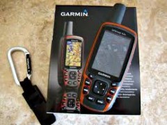
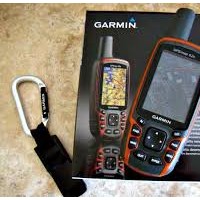

GPS Garmin Map 62S
Gambar Produk
GPS Garmin Map 62S
Update Terakhir
25-10-2016
Minimum Pembelian
1 unit
Dilihat Sebanyak
272 kali
Lokasi
Harga
Rp. 3.700.000
Bagikan
+ Penawaran
Perhatian!
Perusahaan ini terdaftar sebagai Free Member. Hindari melakukan pembayaran sebelum bertemu penjual atau melihat barang secara langsung. COD (Cash On Delivery) atau bertemu langsung dengan penjual merupakan metode transaksi lebih aman.
Spesifikasi GPS Garmin Map 62S
Garmin GPSMap 62S
GPSMAP 62s features a 3-axis tilt-compensated compass, a barometric altimeter and supports Custom Maps, BirdsEye™ Satellite imagery ( subscription required) and photo navigation. Rugged and waterproof, GPSMAP 62s employs a quad helix antenna for unparalleled reception, has a high-speed USB connection, a sleek new design and connects wirelessly to compatible handheld devices.
Explore
GPSMAP 62s comes with built-in worldwide basemap with shaded relief, so you can navigate anywhere with ease. With photo navigation, you can download pictures from Garmin Connect™ Photos and navigate to them.
Get Your Bearings
GPSMAP 62s has a built-in 3-axis tilt-compensated electronic compass, which shows your heading even when you’ re standing still, without holding it level. Its barometric altimeter tracks changes in pressure to pinpoint your precise altitude, and you can even use it to plot barometric pressure over time, which can help you keep an eye on changing weather conditions.
Share Wirelessly
With GPSMAP 62s you can share your waypoints, tracks, routes and geocaches wirelessly with other compatible devices. Your friends can enjoy your favorite hike or cache — simply press “ send” to transfer your information.
Keep Your Fix
With its quad helix antenna and high-sensitivity, WAAS-enabled GPS receiver and HotFix® satellite prediction, GPSMAP 62s locates your position quickly and precisely and maintains its GPS location even in heavy cover and deep canyons. The advantage is clear — whether you’ re in deep woods or just near tall buildings and trees, you can count on GPSMAP 62s to help you find your way when you need it the most.
BirdsEye™ satellite image
Add Maps
Adding more maps is easy with our array of detailed topographic, marine and road maps. With 1.7 GB of onboard memory, you can conveniently download 24K and 100K TOPO mapsand hit the trail, plug in BlueChart® g2 preloaded cards for a great day on the water or City Navigator NT® map data for turn-by-turn routing on roads ( see maps tab for compatible maps) . GPSMAP 62s also supports BirdsEye Satellite Imagery ( subscription required) , that lets you download satellite images to your device and integrate them with your maps. In addition, the 62s is compatible with Custom Maps, free software that transforms paper and electronic maps into downloadable maps for your device.
Get Connected
You' ve been busy exploring and now you want to store and analyze your activities. With a simple connection to your computer and to the Internet, you can get a detailed analysis of your activities and send tracks to your outdoor device using Garmin Connect™ . This one-stop site offers an activity table and allows you to view your activities on a map using Google™ Earth. Explore other routes uploaded by millions of Garmin Connect users and share your experiences on Twitter® and Facebook® . Getting started is easy, so get out there, explore and share.
Find Fun
GPSMAP 62s supports geocaching GPX files for downloading geocaches and details straight to your unit. By going paperless, you' re not only helping the environment but also improving efficiency. GPSMAP 62s stores and displays key information, including location, terrain, difficulty, hints and descriptions, which means no more manually entering coordinates and paper printouts! Simply upload the GPX file to your unit and start hunting for caches. Slim and lightweight, 62s is the perfect companion for all your outdoor pursuits.
Plan Your Next Trip
Take charge of your next adventure with BaseCamp™ , software that lets you view and organize maps, waypoints, routes, and tracks. This free trip-planning software even allows you to create Garmin Adventures that you can share with friends, family or fellow explorers. BaseCamp displays topographic map data in 2-D or 3-D on your computer screen, including contour lines and elevation profiles. It also can transfer an unlimited amount of satellite images to your device when paired with a BirdsEye Satellite Imagery subscription.
Physical & Performance:
Unit dimensions, WxHxD: 2.4 " x 6.3 " x 1.4 " ( 6.1 x 16.0 x 3.6 cm)
Display size, WxH: 1.43 " x 2.15 " ( 3.6 x 5.5 cm) ; 2.6 " diag ( 6.6 cm)
Display resolution, WxH: 160 x 240 pixels
Display type: transflective, 65-K color TFT
Weight: 9.2 oz ( 260.1 g) with batteries
Battery: 2 AA batteries ( not included) ; NiMH or Lithium recommended
Battery life: 20 hours
Waterproof: yes ( IPX7)
Floats: no
High-sensitivity receiver: yes
Interface: high-speed USB and NMEA 0183 compatible
Maps and Memory:
Basemap: yes
Preloaded maps: no
Ability to add maps: yes
Built-in memory: 1.7 GB
Accepts data cards: microSD™ card ( not included)
Waypoints/ favorites/ locations: 2000
Routes: 200
Track log: 10, 000 points, 200 saved tracks
Features and Benefits:
Automatic routing ( turn by turn routing on roads) : yes ( with optional mapping for detailed roads)
Electronic compass: yes ( tilt-compensated, 3-axis)
Touchscreen: no
Barometric altimeter: yes
Camera: no
Geocaching-friendly: yes ( paperless)
Custom maps compatible: yes
Photo navigation ( navigate to geotagged photos) : yes
Hunt/ fish calendar: yes
Sun and moon information: yes
Tide tables: yes
Area calculation: yes
Custom POIs ( ability to add additional points of interest) : yes
Unit-to-unit transfer ( shares data wirelessly with similar units) : yes
Picture viewer: yes
Garmin Connect™ compatible ( online community where you analyze, categorize and share data) : yes
Fax : 021.7302811
Toko Peralatan Survey
CV.BUANA SURVEY
081333102011 atau 021.7321129 ( Nurcahyo)
Menjual Alat Ukur / Alat Survey,Gps Garmin, Gps Trimble, Fluke, Kyoritsu, Hioki, Sanwa, Brunton, Suunto, Sincon, Nikon, Topcon, South, Motorola, Alinco, Icom, Kyoritsu Dan Fluke.Perusahaan Di Bawah Naungan Buana Survey Group,
Menjual,Service Kilibrasi, Alat-Alat Untuk Survey Pemetaan,Kontraktor,Telekomunikasi,Geologi, Exploration ,Kelautan, Militer,Migas, Meteorologi, Klimatologi, dan Geofisika, Laboratorium Industri Pembangunan Pembangunan, Pengelolahan Lahan Lahan Perhutanan Dan Perkebunan Kelapa Sawit. Diantara Alat-Alatnya Sebagai Berikut :
Total Station :
-Total Station Sokkia CX-101, CX-102, CX-103, CX-105, CX-105c
-Total Station Sokkia FX-101, FX-102, FX-103, FX-105
-Total Station Topcon GTS-102N, GTS-255N, GTS-250 Series
-Total Station Topcon ES-101, ES-102, ES-103, ES-105
-Total Station Topcon OS-101, OS-102, OS-103, OS-105
-Total Station Nikon DTM-322, NPL322
-Total Station Nikon Nivo 1M, 2M,3M, 5M
-Total Station Gowin TKS 202
-Total Station Cygnus KS-102
-Total Station South NTS-352L
-Total Station Hi-Target ZTS-320R
-Total Station Ruide RTS 822A, 822R
-Total Station GEO FENNEL FTS 102 , FTD 02
Digital Theodolite :
- Geo FENNEL FET 102KL
- Sokkia DT-540,DT-740
- Topcon DT-205,DT-205L,DT-209,DT-209L
- Nikon NE-100,NE-101,NE-102,NE-103
- South ET-02
- My Surv DT-202C
- GeoMAX ZIPP-02
- Ruide ET02
- Pentax ETH-502
Automatic Level :
- Sokkia B-20,B-30,B-40
- Topcon ATB-2,ATB-3,ATB-4
- Nikon AS-2C,AE-7,AP-8,AC-2S,AX-2S
- Digital Level Orion 2LS
- Digital Level GEOMAX ZDL700
- Digital Level PENTAX AP228
- Digital GEO FENNEL FAL 32
GPS Handheld:
– Garmin GPSMAP 62s
– Garmin GPSMAP 78s
– Garmin GPS Montana 650 kamera 5 MP
– Garmin GPS e-Trex 10,20,30
– Garmin GPS Rino 610– Garmin Nuvi 1350,Nuvi 50LM,
– Garmin GPS Aera 500,Aera 550
– Magellan Explorist 610
Gps Marine :
– Garmin GPSMAP 4012
– Garmin GPSMAP 2108
– Garmin GPSMAP 585
– Garmin GPS 128
– Garmin Radar GMR-18
– Garmin GSD 22
– Garmin Antena GA 30
– Garmin Kabel Transduser
– Garmin Fishfinder Echo 100,300c,500c
– FURUNO GP-32
– FURUNO FCV 620
– FURUNO FCV 627
– FURUNO 1835
– Gps Geodetik Trimble,Topcon,Sokkia,Javad
– Kompas Geologi,Kompas Survey
– Handy Talky
– Radio Rig
– Telepon Satelit
– Walkie Talkie Sepasang
– Teropong Binocular Nikon
– Teropong Binocular Bushnell
– Teropong Malam Night Vision
– Teropong Jarak Bushnell&Nikon;- Peralatan Geologi Explorasi Tambang
– Peralatan Meteorologi
– Peralatan Hidrografi Laut Dan Sungai
– Peralatan Survey Hutan Dll
Tersedia Jasa Service Kalibrasi
Diantaranya :
Total Station - Theodolite - Automatic Level / Waterpass dan Laser level dll
* GRATIS ONGKOS KIRIM !!!! WILAYAH DKI JAKARTA PEMBAYARAN COD DI TEMPAT *

Toko Peralatan Survey
Free Member
jalan muchtar raya no 1d kreo-ciledug
Login Terakhir 18-01-2017
081333102011
081333102011
Produk Lainnya