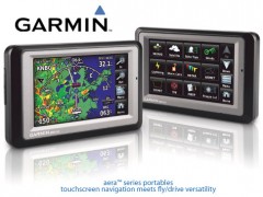
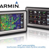

GARMIN Aera 500 Aviation GPS
Perhatian!
Spesifikasi GARMIN Aera 500 Aviation GPS
The Garmin aera 500 from the Garmin 500 series of GPS has a touch screen which easily transforms from flying to driving. Garmin's aera 500 features an intuitive, icon-driven user interface on a 4.3 QVGA widescreen.
With aera, fingertip navigation has entered a whole new era: One that streamlines operation. Eliminates knobs and buttons. Simplifies the pilot/motorist interface. And lets you think in terms of door-to-door guidance, not just runway-to-runway.
Check Out the aera 500
The affordable aera 500 features a crisp 4.3-inch QVGA wide-format touchscreen and pre-loaded graphical mapping, this versatile, feature-rich unit comes ready for takeoff, right out of the box.
Fly aera. Anywhere
In aviation mode, the aera 500's detailed chart-style shaded mapping and extensive terrain and aviation databases help you visualise your flight path in relation to nearby navaids, terrain, SUAs, obstructions, and so on. Plus, the addition of private airports and heliports to the database affords even more navigation and emergency "nearest" options. A database-driven terrain advisory feature offers TAWS-like colour coding and pop-up alerts when possible obstructions or ground proximity conflicts loom ahead. And with terrain/obstacle data shown at standard 30 arc-second resolution, you'll enjoy a surprising level of detail on the display. The unit's graphical Terrain page offers both overhead and vertical profile views of the topography you're flying over. What's more, there's an IFR map mode that lets you display and navigate on high or low enroute airways. You can also pull up MEAs (Minimum Enroute Altitudes) and distances between intersections by touching the airway on the map. As in all the aera models, GPS updating is provided at a super-fast 5 Hz rate. And for added safety, an optional power/data cable makes it easy to interface your aera 500 with the Garmin GTX 330 Mode S transponder in your aircraft, so you can access and display TIS traffic alerts in busy terminal airspace. What's more, you can also use the aera to load communications frequencies into your Garmin SL 40 Comm or SL 30 Nav/Comm transceiver.
Built to Fly. Born to Run
Once your aircraft returns to terra firma, the fun of aera navigation continues with full automotive GPS capability and preloaded City Navigator NT street mapping. In addition, there's built-in Bluetooth support for wireless hands-free calling with your compatible mobile phone. And the aera's built-in "points of interest" database offers helpful guidance to millions of motels, restaurants, gas stations, ATMs, and other local attractions. To further speed your transition from aircraft to automotive mode, a unique "smart mount" for the aera offers instant clip-and-go car navigation.
Garmin Aera 500 Aviation Features
• Easy-to-use touch screen interface
• Bright 4.3" diagonal, color touch screen display; 480 x 272 pixels; WQVGA TFT display with white backlight
• Lithium-ion battery - lasts up to five hours, depending on usage and settings
• Flight Plans: 50 with up to 300 points each
• Flight log: At least 30 most recent flights
• Auto time zone - aera will automatically adjust your time zone while navigating
• High-sensitivity GPS receiver with WAAS position accuracy for improved performance and reception
• Simplified PC connectivity, using USB mass storage for easy data base updates
• Unit dimensions - 5.3"W x 3.3"H x 0.9"D
• Weight - 9.5 oz (270g)
• Rugged and waterproof (IPX-7)
• Interface with SL30 and SL40 for frequency tuning
Aera 500 In-car Features
• Preloaded street maps of Europe and North America
• Turn-by-turn directions with voice guidance - "Turn right on High Street"
• Bluetooth wireless technology - enabling hands-free calling
• Micro-SD card slot for optional mapping and data storage
• Trip computer records mileage, max speed, total time and more
• Garmin Connect Photos - associate your favorite images with saved locations and visit
• Garmin Connect at http://connect.garmin.com to download new images with included coordinates
• Built-in travel kit includes features such as picture viewer, world clock, currency and measurement converters and calculator
What's in the box: Garmin aera 500 GPS, Yoke mount, Automotive friction mount, Vehicle power cable, Battery, USB cable, User's guide and Quick start manuals.
Digital Instrument
Selamat Datang Di
Digital Instrument - Industrial Equipment Online Store
Industrial Equipment - Menjual Berbagai Macam Peralatan Kebutuhan Industri Seperti :
Surveying : Total Station, Digital Theodolite, Automatic Level / Waterpass, Hand Level, Measuring Tape, Measuing Wheel, Laser Distance Meter, Range Finder.
Geology Tools : Compass, Clinometer, Rain Gauge, Altimeter, Palu, Current Meter.
Global Positioning System ( GPS) : Navigation, Aviation, Marine, Sport, Handheld, Geodetic dan Mapping.
Electrical Test Tool : Clamp Meter, Multimeter, pH Meter, Vibration Meter, Sound Level Meter, Light Meter, Thermometer, Anemometer, Tachometer, Oscilloscope, Spectrum Analyzer, Power Supply, Frequency Counter, Function Generator, Audio Generator, Signal Generator.
Communication : Handy-Talkie, Repeater, Satelite Phone.
Teropong : Binocular, Monocular, Telescope, Microscope.


Produk Lainnya


Bange BG8031 Tas Selempang Pria Slin
Rp. 329.000

SEIN | Samsung Note 10+ Plus 12/512G
Rp. 2.015.000

Samsung Galaxy S21 Ultra 5G 16/512GB
Rp. 2.495.000

Laoshidaishu koper pilot 18 Inch rin
Rp. 359.000

Samsung Galaxy A17 8/128GB - Black S
Rp. 2.950.000