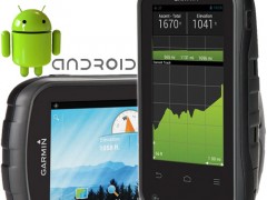
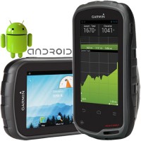

GARMIN Monterra GPS
Perhatian!
Spesifikasi GARMIN Monterra GPS
The Garmin Monterra GPS combines powerful GPS navigation with the versatility of Android OS. Enjoy state-of-the-art routefindiing along with all your favorite Android apps from Google Play.
· Get all your favorite recreational apps on Google Play, as well as a wide range of professional apps that extend your office to the field
· High-sensitivity, WAAS- and GLONASS-enabled GPS receiver locates your position with precision and maintains its GPS location, even under heavy cover and in deep canyons
· 4-in. color multi-touch display uses sunlight and other light along with the LED backlight to increase brightness; conserve power by leaving the backlight turned off
· Load maps such as BirdsEye (subscription required) or TOPO and millions of geocaches with 8GB of internal memory; microSD card slot lets you add 64 GB of additional memory
· 3D MapMerge combines maps and lets you view them in rich 3D with textures such as hills, valleys, lakes and forests; zoom in, pan out and rotate using the multi-touch screen
· 8 megapixel autofocus digital camera with LED flash takes vivid, geo-tagged photos for easy return navigation; 1080p HD video camera captures sharp and clear footage
· 3-axis electronic compass with accelerometer and gyro shows where you're heading, even when you’re standing still or not holding the Monterra level
· Barometric altimeter tracks changes in pressure to pinpoint your altitude; you can even use it to plot barometric pressure over time to keep an eye on changing weather
· FM and NOAA weather radio with SAME alerts let you tune in to location-specific watches and warnings; listen with headphones (sold separately) or through the built-in speaker
· UV sensor lets you know your exposure level to sunlight so you can avoid sun damage, especially at higher elevations and on bright or reflective surfaces such as snow or water
· Wi-Fi, ANT+, Bluetooth and NFC wireless connections let you share your data, maps, waypoints, tracks, routes and geocaches at blazing speeds with other compatible devices
· Download caches from OpenCaching and GSAK or use your favorite app to read descriptions, hints and logs; view cache photos and filter by size, terrain, difficulty and type
· Included BaseCamp software lets you view and organize maps, waypoints, routes and tracks in 2D or 3D with contour lines and elevation profiles on your computer
· Dual battery system lets you use the included rechargeable lithium ion pack or standard AA batteries; the lithium-ion pack charges when device is connected to external power
MapSource™ features data in DVD format to augment the info already on your GPS basemap. It allows you to view color maps on a computer with zoom/pan functions for easy map browsing. You can select maps in areas of interest and transfer them to a compatible GPS. English language only.
Digital Instrument
Selamat Datang Di
Digital Instrument - Industrial Equipment Online Store
Industrial Equipment - Menjual Berbagai Macam Peralatan Kebutuhan Industri Seperti :
Surveying : Total Station, Digital Theodolite, Automatic Level / Waterpass, Hand Level, Measuring Tape, Measuing Wheel, Laser Distance Meter, Range Finder.
Geology Tools : Compass, Clinometer, Rain Gauge, Altimeter, Palu, Current Meter.
Global Positioning System ( GPS) : Navigation, Aviation, Marine, Sport, Handheld, Geodetic dan Mapping.
Electrical Test Tool : Clamp Meter, Multimeter, pH Meter, Vibration Meter, Sound Level Meter, Light Meter, Thermometer, Anemometer, Tachometer, Oscilloscope, Spectrum Analyzer, Power Supply, Frequency Counter, Function Generator, Audio Generator, Signal Generator.
Communication : Handy-Talkie, Repeater, Satelite Phone.
Teropong : Binocular, Monocular, Telescope, Microscope.


Produk Lainnya

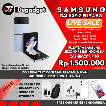
SEIN Samsung Galaxy Z Flip 4 & 3 5G
Rp. 3.720.000
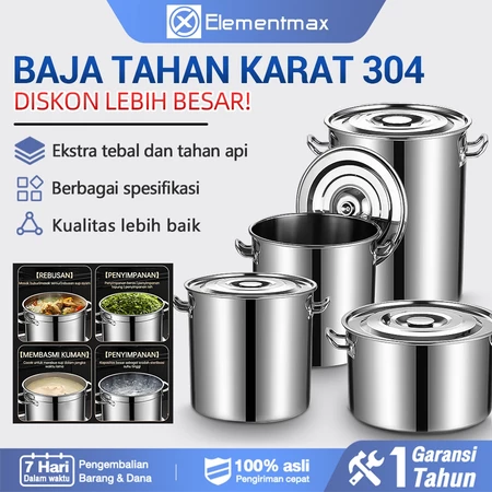
Panci Dandang Stainless Steel Tebal
Rp. 112.000
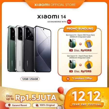
Xiaomi 14 (12/256GB) | Snapdragon®
Rp. 10.550.000

BAGSMART Tote Bag Expandable 28L Duf
Rp. 381.000

Modul Surya Trina Solar N-type i-TOP
CALL