


MapInfo Professional v11.5
Perhatian!
Spesifikasi MapInfo Professional v11.5
MapInfo Professional v11.5 includes significant improvements as requested by users, such as:
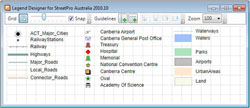
Create better legends
|
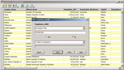
Faster, intuitive browser window
|
|
Easily maintain your metadata
|
Other requested enhancements
|
|
FEATURES AND BENEFITS
Data Access
Built-in support lets you access and view a variety of data formats directly. So you can view Microsoft Excel, Microsoft Access or database data such as Oracle, Microsoft SQL Server, as well as many other file formats, out of the box. You can also view images of virtually any format, ensuring that MapInfo Professional fits your current IT structure with no additional cost.
Data Creation and Editing
Provides many CAD data creation and editing tools as well as the ability to edit tabular data (values and names). Make all your changes for maps and data in one application and save time and effort.
Data Processing
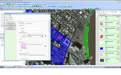
Spatial data processing is where you can see the power of MapInfo Professional. Perform geographic queries on customer data such as “Show me all customers within a kilometre of my office.” Instantly create trade areas based on common geographic variables (proximity to a major road or sales territory). Derive new insights and data by joining or splitting geographic regions (postcode boundaries). Create exclusive trade areas for all your service centres.
Display
Instantly shade/change style or mark territories (using any symbol, graduated symbols, charts or graphs), boundaries, highways, fibre lines or points based on any tabular data values through a simple wizard. You can also aggregate values using statistical or any math functions to associate a symbol or a colour to a point or a region based on a calculated value. For example, shade the sales territories based on number of customers. Trends based on geography reveal themselves, patterns become clear and better decisions with impact are imminent.
Data and Map Publishing
In today’s IT environment, the need to have multiple publishing options is critical to meaningful communication between applications. Choose between a suite of PDF publishing options including standard PDF, layered PDF and now geo-registered PDF. This enables you to share more than just maps with your colleagues, but location-based answers. In addition, MapInfo Professional is web-enabled. Publish static or interactive maps through easy-to-use wizards. Share the results in a format that best fits your needs. Add MapInfo Stratus, and you gain 24/7 access to location-based data and analysis via the cloud—ideal for disseminating public information, enabling business users to fulfill mapping requests, and sharing geo-based enterprise data with co-workers, citizens, constituents and customers.
SPECIFICATIONS
Our products are designed to work within a wide variety of existing technical environments.
Supported Operating Systems:
- Windows XP Professional 32-bit Service Pack 3 (SP3)
- Windows 7 Ultimate 32-bit SP1
- Windows 7 Ultimate 64-bit SP1 with 32-bit compatibility mode
- Windows 2008 Server 32-bit SP2
- Windows 2008 Server R2 64-bit SP1 with XenServer 6.0
- Windows 2008 Server R2 64-bit SP1
Supported Databases:
XY - i.e. Databases that store point data as X & Y numeric columns:
- Microsoft Access 2007, 2010
- Microsoft SQL Server 2005 and 2008
- Microsoft SQL Server 2008 XY on a spatialised DB
- Oracle Spatial 10Gr2, 11Gr2
Supported Spatial - Databases that store map data as objects including: points lines and regions
- Microsoft SQL Server 2005 with SpatialWare 4.9
- Microsoft SQL Server 2008 (also called SQL Server Spacial)
- Microsoft SQL Server 2012 (also called SQL Server Spacial)
- Oracle Spatial 11Gr2, 10Gr2.
- PostgreSQL 9.0.3 with PostGIS 1.5
Supported Languages:
- English
- French
- German
- Italian
- Spanish
- Danish
- Finnish
- Japanese
- Simplified Chinese
- Swedish
- Dutch
- Czech
- Hebrew
- Korean
- Polish
- Brazilian Portuguese
- Russian
- Turkish
Hub Vivi Olivia
Jl.Rimbawan III Samarinda kalimantan Timur
Mobile 081250956580
PT.GIS GLOBAL SURVEY
Alat Barat. Excavator. Khobelco.Traktor.Bomag.Vibro.
Salam Kami


Produk Lainnya


SANEX RICE COOKER / MAGIC COM MC-258
Rp. 189.500

Leedoo Sepatu Casual Pria Sneakers S
Rp. 116.500

Mesin cetak pellet vertikal 3 roler,
Rp. 7.200.000

EXCLUSIVE TR1PRO jam tangan pintar |
Rp. 660.000

Elementmax 6 Kepala Pijat Elektrik M
Rp. 299.000