


Jual Geodetik Topcon Hiper SR GPS Geodetik Topcon Hiper SR RTK & Static
Gambar Produk
Jual Geodetik Topcon Hiper SR GPS Geodetik Topcon Hiper SR RTK & Static
Brand
GPS Geodetik Topcon Hiper SR
Pengiriman
1 Hari Setelah Pembayaran
Lokasi
Banten - Tangerang - Larangan
Harga
Kontak Kami
Dilihat Sebanyak
87 kali
Update Terakhir
28-01-2026
Bagikan
+ Penawaran
Perhatian!
Perusahaan ini terdaftar sebagai Free Member. Hindari melakukan pembayaran sebelum bertemu penjual atau melihat barang secara langsung. COD (Cash On Delivery) atau bertemu langsung dengan penjual merupakan metode transaksi lebih aman.
Spesifikasi Jual Geodetik Topcon Hiper SR GPS Geodetik Topcon Hiper SR RTK & Static
PRIMA AKRINDO
Jl.Chairil Anwar No.46
Kereo-Larangan
Tangerang-Banten 15156
Telp/Contac Person
Muhammad Arip
081294376475
087884008158
088210149196
email:
m_aripprimaakrindo@yahoo.com
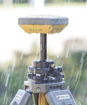
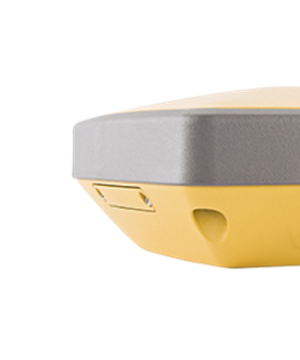
Jual GPS Geodetik Topcon Hiper SR
Penerima GNSS utama Topcon '' 'dalam receiver GNSS yang cerdas, padat, ultra-kasar.
Ringan namun cukup tangguh untuk bertahan dari penurunan 2m, dan cukup adonan isi ulang selama 20 jam berturut-turut operasi! SR HiPer baru dengan konfigurasi seluler opsional menambahkan peluang luar biasa ke situs pekerjaan Anda. Receiver terintegrasi dari Topcon '' 's HiPer SR beroperasi tanpa kabel, tanpa antena, pintu baterai, atau konektor. HiPer SR memiliki 226 saluran, pelacakan universal yang mampu chip Vanguard untuk fleksibilitas kinerja yang tak tertandingi untuk memenuhi kebutuhan semua pekerjaan, besar atau kecil. Gunakan satu SR untuk GNSS statis cepat dan akurat atau sebagai jaringan RTK dengan menambahkan fungsionalitas jaringan dan pengontrol berkemampuan seluler. Gunakan sepasang untuk basis ekonomis dan jalankan solusi RTK atau dengan solusi komunikasi Longlink Topcon untuk solusi kecil di seluruh situs yang sempurna. Bagian terbaik? Ada '' HiPer SR yang sesuai dengan anggaran Anda.
Kekuasaan. Kinerja. Harga. Dengan SR HiPer, semuanya cocok di telapak tangan Anda.
Fitur termasuk:
226-channel Vanguard technology dengan Universal Tracking Channels
Penentuan Posisi Hybrid
Desain yang ringkas, ringan, dan kasar
Receiver, antena, baterai, memori, dan komunikasi yang terintegrasi sepenuhnya
Teknologi multi-channel Longlink ™ komunikasi terpadu
Baterai tersegel menyediakan hingga 20 jam operasi
Mengurangi layar MINTER, dengan operasi satu tombol
Pengisian (serial dan daya) dan port USB saja
Konfigurasi seluler (opsional)
Akurasi posisi:
>> Akurasi Statis
- Horizontal (3 mm + 0,8 ppm RMS)
- Vertikal (4 mm + 1 ppm RMS)
>> Akurasi RTK
- Horisontal (10 mm + 1 ppm RMS)
- Vertikal (15 mm + 1 ppm RMS)
Teknologi RTK Jangkauan Panjang dengan Bluetooth R: 300 Meter, Daiameter: 600 Meter
Satu Basis dapat dihubungkan dengan 3 Rover serentak
Memori Internal 4 GB
Versi RTCM 2.x modul memiliki input dan output 3.x, NMEA dan NTRIP
Perlindungan debu dan air IP 67
Shock Rating: 2 pole drop concerte
Operasi Battere: kira-kira 20 jam untuk Mode statis
Tersedia Indikasi Lampu untuk Satelite Total, memori, masa pakai baterai, dan komunikasi data
Dapat melakukan penggambaran langsung garis, titik dan poligon ketika pengukuran survei
Mampu Menampilkan informasi berupa bidang, luas dan keliling bidang, panjang garis batas,
Mampu mengimpor data titik dari excel dan melakukan titik pengintaian untuk rekonstruksi
Mampu mengimpor data gambar dan melakukan pengintaian langsung dari Bidang Gambar
Dapat menampilkan peta dasar latar raster dan vektor
Lapisan dapat dibuat langsung di lapangan dan dapat dibaca pada perangkat lunak CAD yang ada
Mampu mengimpor dan mengekspor file dalam bentuk shp, dxp, DWG, csv, txt, dll.
Gps Garmin (Darat Laut Udara):
Gps Garmin Etrex 10
Gps Garmin Etrex 30
Gps Garmin Gpsmap 64s
Gps Garmin Gpsmap 64sc
Gps Garmin Gpsmap 78s
Gps Garmin Oregon 750
Gps Garmin Montana 680
Gps Garmin Monterra
Garmin Fishfinder 350c
Garmin Fishfinder 350 Plus
Garmin Fishfinder 560c
Garmin Gps 158
Garmin Gpsmap 585
Garmin Gpsmap 585 Plus
Garmin Aquamap 80xs
Garmin Aquamap 100xs
Garmin Aera 500
Garmin Aera 660
Garmin Nuvi
Garmin Radar GMR-18
Garmin GSD 22
Garmin Antena GA 30
Garmin Kabel Transduser
Gps Trimble :
Gps Trimble Juno 3B
Gps Trimble Juno 3D
Gps Trimble Juno SD
GPS Trimble Juno 5B
GPS Trimble Juno 5D
GPS Trimble GeoXH 6000
GPS Trimble GeoXT 6000
Gps Geodetik
Gps/Gnss Geodetik RTK & Static :
Gps Geodetik Topcon HiPer SR
Gps Geodetik Topcon GR 5
Gps Geodetik Topcon HiPer V
Gps Geodetik Sokkia GRX 2
Gps Geodetik Sokkia GCX 2
Gps Geodetik Ruide R90X
GPS Geodetik Ruide NOVA R6
GPS Geodetik Ruide R70 Statik
Gps Geodetik South S86S
Gps Geodetik South Galaxy G1
GPS Geodetik South GALAXY G6
GPS Geodetik South H66 Statik L1
Gps Geodetik South S86S Dual Frekuensi
GPS Geodetic Trimble R10 L1 L2 L2c L5
GPS Glonass GNSS Galileo Compass x Fill TSC3
GPS Geodetic Trimble R4
Gps Geodetik Geo Fennel FGS 1
Hi Target V90 ( GNSS RTK & Static)
Hi Target V60 ( GNSS RTK & Static)
Hi Target V30 ( GNSS RTK & Static)
Hi Target V30XT ( L1 GPS Static)
Spectra Precision ProMark 120 ( L1 GPS+Glonass)
Spectra Precision ProMark 120 ( L1 GPS )
Gps Geodetik Horizon Kronos C3
GPS Geodetic Horizon Kronos 100 L1
Gps Geodetik CHC X900
Gps Geodetik Acnovo GINTEC G10 Glonass
RTK GPS Geodetik CHC-i70
Gps Geodetik CHC-X91 RTK, GNNS
Gps Geodetik CHC i80RTK-GNNS
GPS Geodetik CHCM5
Gps Geodetik Acnovo GX-9
GPS Geodetik STonEX S8 RTK
Alat Survey Topcon :
Total Station GTS 102N
Total Station ES 62,ES 65
Total Station ES-101, ES-102, ES-103, ES-105, ES-107
Total Station OS-101, OS-102, OS-103, OS-105, OS-107
Total Station QS-101, QS-102, QS-103, QS-105, QS-107
Digital Theodolite Topcon 209/Topcon 209L
Digital Theodolite Topcon 207/Topcon 207L
Digital Theodolite Topcon 205/Topcon 205L
Digital Theodolite Topcon 202/Topcon 202L
Automatic Level Topcon ATB-2
Automatic Level Topcon ATB-3A
Automatic Level Topcon ATB-4A
Alat Survey Sokkia :
Total Station Sokkia CX 101
Total Station Sokkia CX 102
Total Station Sokkia CX 103
Total Station Sokkia CX 105
Total Station Sokkia CX 107
Digital Theodolite DT-940/DT-940L
Digital Theodolite DT-740/DT-740L
Digital Theodolite DT-540/DT-540L
Digital Theodolite DT-240/DT-240L
Automatic Level Sokkia B40A
Automatic Level Sokkia B30A
Automatic Level Sokkia B20
Alat Survey Nikon :
Total Station Nikon DTM 322
Total Station Nikon DTM 652
Total Station Nikon NPL 632
Total Station Nikon Nivo 2M
Total Station Nikon Nivo 3M
Total Station Nikon Nivo 5M
Total Station Nikon Nivo 2C
Total Station Nikon Nivo 3C
Total Station Nikon Nivo 5c
Digital Theodolite NE-101
Digital Theodolite NE-102
Digital Theodolite NE-103
Automatic Level Nikon AC-2S
Automatic Level Nikon AP-8
Automatic Level Nikon AS-2C
Alat Survey South :
Total Station South NTS 332R
Total Station South NTS-355L
Total Station South NTS 325
Digital Theodolite ET-02/ET-02L
Digital Theodolite ET-05/ET-05L
Alat Survey Ruide :
Digital Theodolite Ruide ET-02/ET-02L
Total Station Ruide RTS 822A, 822R
Alat Ukur Leica Disto :
Leica Disto D210 New
Leica Disto x310
Leica Disto D3abt
Leica Disto D510
Leica Disto D810
Global Water flow probe FP 111
Current Meter Flowatch FL-03
Geopac Current Meter
Davis Vantaga Pro 2
Solint Water Level Meter 101
Penakar Curah Type Hellman
Tabung Curah Hujan Galpanis
Penakar Hujan Nyelex 1000
Penakar Hujan Neta
Kompas Brunton (5008,5006,5010)
Kompas Suunto (KB 20,KB14,Clinometer,Tandem)
Kompas Silva
Kompas DQL
Palu Geologi Estwing (Runcing)
Palu Geologi Estwing (Pipih)
Haga Meter/Haga Altimeter
Speed Gun Bushnell
Teropong/Binocular
Louper (Kaca Pembesar)
Measuring Whell/Meteran Dorong
Digital Planimeter Placom KP N90
Diameter Tape
Handy Talky (Motorola,Alinco,VEV)
Telepon Satelite (Thuraya,Isat phone)
Perahu Karet (Virgo,Zebec,Avon,Acisa)
Almunium Tripod
Rambu ukur (3m,5m,7m)
Jl.Chairil Anwar No.46
Kereo-Larangan
Tangerang-Banten 15156
Telp/Contac Person
Muhammad Arip
081294376475
087884008158
088210149196
email:
m_aripprimaakrindo@yahoo.com
Jual GPS Geodetik Topcon Hiper SR
Penerima GNSS utama Topcon '' 'dalam receiver GNSS yang cerdas, padat, ultra-kasar.
Ringan namun cukup tangguh untuk bertahan dari penurunan 2m, dan cukup adonan isi ulang selama 20 jam berturut-turut operasi! SR HiPer baru dengan konfigurasi seluler opsional menambahkan peluang luar biasa ke situs pekerjaan Anda. Receiver terintegrasi dari Topcon '' 's HiPer SR beroperasi tanpa kabel, tanpa antena, pintu baterai, atau konektor. HiPer SR memiliki 226 saluran, pelacakan universal yang mampu chip Vanguard untuk fleksibilitas kinerja yang tak tertandingi untuk memenuhi kebutuhan semua pekerjaan, besar atau kecil. Gunakan satu SR untuk GNSS statis cepat dan akurat atau sebagai jaringan RTK dengan menambahkan fungsionalitas jaringan dan pengontrol berkemampuan seluler. Gunakan sepasang untuk basis ekonomis dan jalankan solusi RTK atau dengan solusi komunikasi Longlink Topcon untuk solusi kecil di seluruh situs yang sempurna. Bagian terbaik? Ada '' HiPer SR yang sesuai dengan anggaran Anda.
Kekuasaan. Kinerja. Harga. Dengan SR HiPer, semuanya cocok di telapak tangan Anda.
Fitur termasuk:
226-channel Vanguard technology dengan Universal Tracking Channels
Penentuan Posisi Hybrid
Desain yang ringkas, ringan, dan kasar
Receiver, antena, baterai, memori, dan komunikasi yang terintegrasi sepenuhnya
Teknologi multi-channel Longlink ™ komunikasi terpadu
Baterai tersegel menyediakan hingga 20 jam operasi
Mengurangi layar MINTER, dengan operasi satu tombol
Pengisian (serial dan daya) dan port USB saja
Konfigurasi seluler (opsional)
Akurasi posisi:
>> Akurasi Statis
- Horizontal (3 mm + 0,8 ppm RMS)
- Vertikal (4 mm + 1 ppm RMS)
>> Akurasi RTK
- Horisontal (10 mm + 1 ppm RMS)
- Vertikal (15 mm + 1 ppm RMS)
Teknologi RTK Jangkauan Panjang dengan Bluetooth R: 300 Meter, Daiameter: 600 Meter
Satu Basis dapat dihubungkan dengan 3 Rover serentak
Memori Internal 4 GB
Versi RTCM 2.x modul memiliki input dan output 3.x, NMEA dan NTRIP
Perlindungan debu dan air IP 67
Shock Rating: 2 pole drop concerte
Operasi Battere: kira-kira 20 jam untuk Mode statis
Tersedia Indikasi Lampu untuk Satelite Total, memori, masa pakai baterai, dan komunikasi data
Dapat melakukan penggambaran langsung garis, titik dan poligon ketika pengukuran survei
Mampu Menampilkan informasi berupa bidang, luas dan keliling bidang, panjang garis batas,
Mampu mengimpor data titik dari excel dan melakukan titik pengintaian untuk rekonstruksi
Mampu mengimpor data gambar dan melakukan pengintaian langsung dari Bidang Gambar
Dapat menampilkan peta dasar latar raster dan vektor
Lapisan dapat dibuat langsung di lapangan dan dapat dibaca pada perangkat lunak CAD yang ada
Mampu mengimpor dan mengekspor file dalam bentuk shp, dxp, DWG, csv, txt, dll.
Gps Garmin (Darat Laut Udara):
Gps Garmin Etrex 10
Gps Garmin Etrex 30
Gps Garmin Gpsmap 64s
Gps Garmin Gpsmap 64sc
Gps Garmin Gpsmap 78s
Gps Garmin Oregon 750
Gps Garmin Montana 680
Gps Garmin Monterra
Garmin Fishfinder 350c
Garmin Fishfinder 350 Plus
Garmin Fishfinder 560c
Garmin Gps 158
Garmin Gpsmap 585
Garmin Gpsmap 585 Plus
Garmin Aquamap 80xs
Garmin Aquamap 100xs
Garmin Aera 500
Garmin Aera 660
Garmin Nuvi
Garmin Radar GMR-18
Garmin GSD 22
Garmin Antena GA 30
Garmin Kabel Transduser
Gps Trimble :
Gps Trimble Juno 3B
Gps Trimble Juno 3D
Gps Trimble Juno SD
GPS Trimble Juno 5B
GPS Trimble Juno 5D
GPS Trimble GeoXH 6000
GPS Trimble GeoXT 6000
Gps Geodetik
Gps/Gnss Geodetik RTK & Static :
Gps Geodetik Topcon HiPer SR
Gps Geodetik Topcon GR 5
Gps Geodetik Topcon HiPer V
Gps Geodetik Sokkia GRX 2
Gps Geodetik Sokkia GCX 2
Gps Geodetik Ruide R90X
GPS Geodetik Ruide NOVA R6
GPS Geodetik Ruide R70 Statik
Gps Geodetik South S86S
Gps Geodetik South Galaxy G1
GPS Geodetik South GALAXY G6
GPS Geodetik South H66 Statik L1
Gps Geodetik South S86S Dual Frekuensi
GPS Geodetic Trimble R10 L1 L2 L2c L5
GPS Glonass GNSS Galileo Compass x Fill TSC3
GPS Geodetic Trimble R4
Gps Geodetik Geo Fennel FGS 1
Hi Target V90 ( GNSS RTK & Static)
Hi Target V60 ( GNSS RTK & Static)
Hi Target V30 ( GNSS RTK & Static)
Hi Target V30XT ( L1 GPS Static)
Spectra Precision ProMark 120 ( L1 GPS+Glonass)
Spectra Precision ProMark 120 ( L1 GPS )
Gps Geodetik Horizon Kronos C3
GPS Geodetic Horizon Kronos 100 L1
Gps Geodetik CHC X900
Gps Geodetik Acnovo GINTEC G10 Glonass
RTK GPS Geodetik CHC-i70
Gps Geodetik CHC-X91 RTK, GNNS
Gps Geodetik CHC i80RTK-GNNS
GPS Geodetik CHCM5
Gps Geodetik Acnovo GX-9
GPS Geodetik STonEX S8 RTK
Alat Survey Topcon :
Total Station GTS 102N
Total Station ES 62,ES 65
Total Station ES-101, ES-102, ES-103, ES-105, ES-107
Total Station OS-101, OS-102, OS-103, OS-105, OS-107
Total Station QS-101, QS-102, QS-103, QS-105, QS-107
Digital Theodolite Topcon 209/Topcon 209L
Digital Theodolite Topcon 207/Topcon 207L
Digital Theodolite Topcon 205/Topcon 205L
Digital Theodolite Topcon 202/Topcon 202L
Automatic Level Topcon ATB-2
Automatic Level Topcon ATB-3A
Automatic Level Topcon ATB-4A
Alat Survey Sokkia :
Total Station Sokkia CX 101
Total Station Sokkia CX 102
Total Station Sokkia CX 103
Total Station Sokkia CX 105
Total Station Sokkia CX 107
Digital Theodolite DT-940/DT-940L
Digital Theodolite DT-740/DT-740L
Digital Theodolite DT-540/DT-540L
Digital Theodolite DT-240/DT-240L
Automatic Level Sokkia B40A
Automatic Level Sokkia B30A
Automatic Level Sokkia B20
Alat Survey Nikon :
Total Station Nikon DTM 322
Total Station Nikon DTM 652
Total Station Nikon NPL 632
Total Station Nikon Nivo 2M
Total Station Nikon Nivo 3M
Total Station Nikon Nivo 5M
Total Station Nikon Nivo 2C
Total Station Nikon Nivo 3C
Total Station Nikon Nivo 5c
Digital Theodolite NE-101
Digital Theodolite NE-102
Digital Theodolite NE-103
Automatic Level Nikon AC-2S
Automatic Level Nikon AP-8
Automatic Level Nikon AS-2C
Alat Survey South :
Total Station South NTS 332R
Total Station South NTS-355L
Total Station South NTS 325
Digital Theodolite ET-02/ET-02L
Digital Theodolite ET-05/ET-05L
Alat Survey Ruide :
Digital Theodolite Ruide ET-02/ET-02L
Total Station Ruide RTS 822A, 822R
Alat Ukur Leica Disto :
Leica Disto D210 New
Leica Disto x310
Leica Disto D3abt
Leica Disto D510
Leica Disto D810
Global Water flow probe FP 111
Current Meter Flowatch FL-03
Geopac Current Meter
Davis Vantaga Pro 2
Solint Water Level Meter 101
Penakar Curah Type Hellman
Tabung Curah Hujan Galpanis
Penakar Hujan Nyelex 1000
Penakar Hujan Neta
Kompas Brunton (5008,5006,5010)
Kompas Suunto (KB 20,KB14,Clinometer,Tandem)
Kompas Silva
Kompas DQL
Palu Geologi Estwing (Runcing)
Palu Geologi Estwing (Pipih)
Haga Meter/Haga Altimeter
Speed Gun Bushnell
Teropong/Binocular
Louper (Kaca Pembesar)
Measuring Whell/Meteran Dorong
Digital Planimeter Placom KP N90
Diameter Tape
Handy Talky (Motorola,Alinco,VEV)
Telepon Satelite (Thuraya,Isat phone)
Perahu Karet (Virgo,Zebec,Avon,Acisa)
Almunium Tripod
Rambu ukur (3m,5m,7m)
Prima Akrindo Online Store
Prima Akrindo adalah situs belanja online terpecaya di Indonesia untuk alat-alat teknik seperti : GPS (Global Positioning System) dengan beragam jenis GPS seperti GPS navigasi, GPS survey, GPS marine, GPS aviasi, GPS pemetaan, GPS geodetik, dari merek GARMIN, MAGELLAN, TRIMBLE, SPECTRA. Alat Survey meliputi autolevel/waterpass, theodolite digital, total station, kompas survey, clinometer, tandem, kompas geologi, palu geologi estwing, planimeter, measuring tape, measuring wheel, rambu ukur, prisma. Alat Ukur / instrumen meliputi alat ukur arus air atau current meter flowatch flow probe, ph meter, curah hujan, laser distance meter leica disto, davis weather station. Alat Komunikasi meliputi Telepon Satelit merek INMARSAT, THURAYA, IRIDIUM, radio HT, radio RIG, radio SSB.perlengkapan safety, perahu karet, binocular, range finder, night vision.Tlp.081294376475/087884008158/088210149196
Free Member
JL,CHAIRIL ANWAR NO.46
Banten - Tangerang
Login Terakhir 05-02-2026
081294376475
081294376475
081294376475


Produk Lainnya

New BM300 yang Ditingkatkan ANCEL BM
Rp. 470.000

Obat Stroke Angkung Original Sobat H
Rp. 600.000

Dr.isla Nebulizer Portable Mesh Alat
Rp. 179.000

Cani Sepatu Kanvas Wanita Korean Fas
Rp. 116.000

Obat Gerd Asam Lambung Paling Ampuh
Rp. 275.000